
Stream web maps, tiles, features and data
Overview – A Universal Map Server
CubeWerx is a pioneer in Web Mapping and Open Standards. CubeSERV® was the first commercial web map server ever brought to market. Under constant development for over 15 years, it is now the most mature, efficient and standards-compliant web map server available. Over the years it has evolved and adapted to the changing environments that have become the modern Internet, but the driving goals behind its design have always been efficiency and performance.
It will support more users using fewer resources than any competing solution, while remaining rigorously compliant to open web mapping standards. Its OGC complaint APIs are supported by every major desktop and web mapping application and toolkit on the market.
A central component of the Stratos Geospatial Platform, CubeSERV will stream maps, tile, features and imagery data to any device or application.
Standards First
CubeWerx has worked tirelessly to ensure CubeSERV remains the gold standard for OGC compliance, performance and reliability. It is unparalleled in its ability to rapidly compose and serve maps from disparate data sources in complex, multi-user network environments.
It’s comprehensive symbology engine fully supports the OGC Styled Layer Descriptor (SLD) standard, allowing users to dynamically create striking customized maps. Always up-to-date with the latest OGC standards, yet completely backwards compatible with older versions.
It guarantees that your development efforts will be focused on your projects, not on dealing with the complexities of myriad incompatible map servers.
What is a “cascading”
map server?
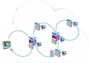
The power of cascading
Unique in the industry, CubeSERV is capable of connecting to other “downstream” map servers, retrieving their capabilities, and presenting them as its own. It can retrieve layers from these other servers and integrate them into a seamless map, regardless of the limitations of the downstream servers, or the versions of the various protocols they support. It will automatically augment the abilities of the other servers as required to provide extra coordinate systems and image formats, etc.
Scales With Your Business
CubeSERV is highly optimized for performance and scalability and a single instance will have no problem handling several hundred simultaneous users using very modest computational resources. And when you are ready to grow, it grows with you. The architecture is designed to run in elastic computing environments such as Amazon’s EC2/ELB framework, allowing the number of map server instances to grow and shrink automatically based on demand. This guarantees reliable, predictable performance, independent from the load on the system.
CubeSERV is a component of the Stratos Geospatial Platform.

® “CubeSERV” is a registered trademark of CubeWerx Inc (Canada) and CubeWerx Corp. (USA)
Let us show you how CubeWerx can boost your productivity
